By Survival Boys Editorial Team
Modern technology has changed the way people travel through the outdoors. Smartphones, vehicle navigation systems, satellite maps, and handheld GPS units have made navigation faster and easier than at any other point in history. With a few taps on a screen, people can pinpoint their location almost instantly.
But technology has weaknesses.
Batteries die. Signals disappear. Devices break. Storms interfere with communication systems. In survival situations, dependence on electronics can quickly become dangerous if backup navigation skills do not exist.

That is why wilderness navigation remains one of the most important outdoor survival skills a person can learn.
For thousands of years, humans crossed forests, mountains, deserts, and oceans without satellites or digital maps. Hunters, explorers, soldiers, and travelers survived because they learned how to observe the world around them carefully. Modern navigation tools may be convenient, but understanding natural navigation methods provides security when technology fails.
One of the biggest mistakes inexperienced outdoorsmen make is relying completely on GPS without paying attention to terrain. Many people follow digital directions blindly while remaining mentally disconnected from their surroundings. If the device suddenly stops working, they may realize they have no understanding of where they actually are.
Experienced navigators constantly observe landmarks, terrain features, weather patterns, and travel direction even while using modern tools. Good navigation begins with awareness.
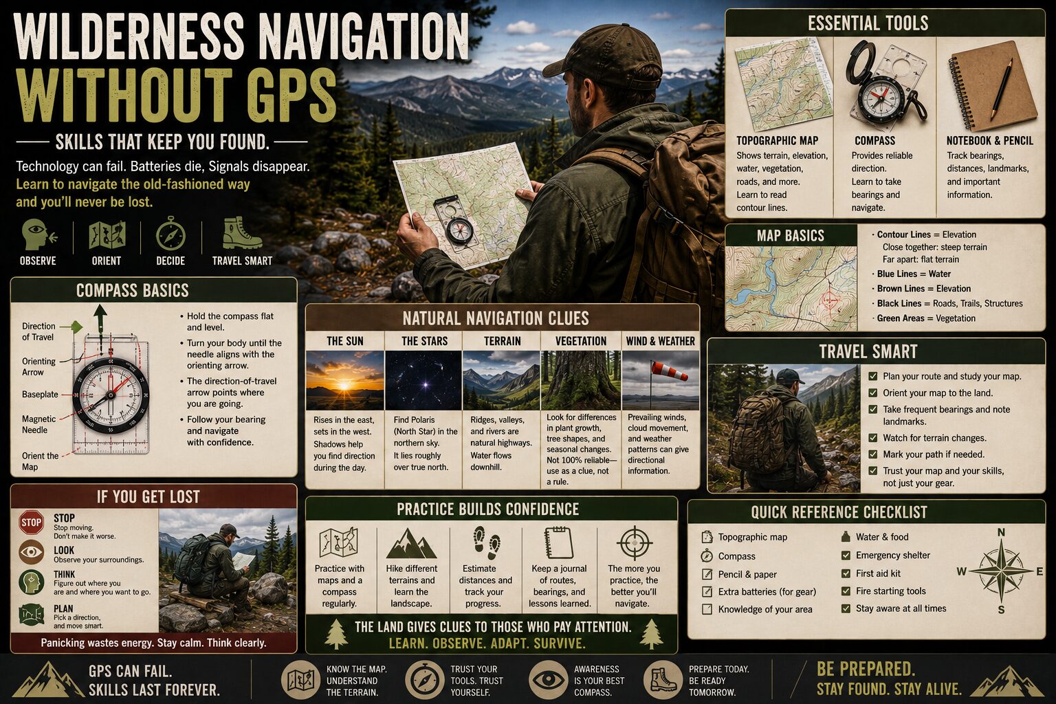
Maps remain one of the most reliable navigation tools ever created because they require no batteries or signal. A quality topographic map reveals terrain details like elevation, rivers, valleys, ridges, roads, and trails. Learning how to read contour lines allows outdoorsmen to visualize the shape of the land long before reaching it physically.
Steep contour lines indicate sharp elevation changes, while wider spacing suggests flatter terrain. Rivers, ridgelines, and mountain saddles become easier to recognize once someone understands how terrain appears on a map.
A compass becomes extremely powerful when combined with map-reading skills. Contrary to popular belief, compasses are not complicated devices reserved only for experts. At their core, they simply provide reliable directional reference.
True navigation skill comes from combining compass direction with terrain interpretation.
Many survival instructors teach the importance of orienting the map first. When the map aligns with the real landscape, terrain features become much easier to recognize and follow. Rivers, valleys, roads, and ridges begin matching the environment naturally instead of appearing as abstract symbols on paper.
One of the most important navigation concepts is maintaining situational awareness at all times. Skilled outdoorsmen rarely travel aimlessly from one point to another. They constantly track landmarks, direction changes, elevation shifts, and surrounding terrain.
This habit prevents disorientation before it begins.
Getting lost usually happens gradually. A missed trail marker, poor visibility, overconfidence, fatigue, or distraction slowly pulls people off course until confusion builds. By the time panic appears, the situation may already be serious.
Natural navigation methods become extremely valuable when tools fail completely. The sun provides one of the oldest directional references in human history. In the Northern Hemisphere, the sun generally rises in the east and sets in the west, though seasonal variation changes the exact positioning.
Shadows also reveal directional clues throughout the day. While not precise enough for detailed navigation alone, solar awareness helps maintain general orientation when other tools are unavailable.
At night, the stars become powerful navigational references. Polaris, commonly called the North Star, remains one of the most reliable celestial markers because it stays relatively fixed above true north in the Northern Hemisphere. Finding Polaris allows travelers to establish direction even in complete wilderness darkness.
Traditional navigation methods often depended heavily on environmental observation. Moss growth, prevailing wind patterns, river flow, snow melt, vegetation density, and animal trails can all provide useful clues when interpreted carefully. However, these signs should never be treated as absolute rules because local conditions vary greatly.
For example, many people believe moss always grows on the north side of trees. In reality, moss grows wherever moisture and shade conditions allow it to thrive. Depending on terrain and climate, this can occur in multiple directions.
Good survival navigation relies on combining multiple clues instead of depending on a single sign.
Terrain association is another critical skill. Rather than focusing only on compass bearings, experienced navigators learn to “read” landscapes. Valleys guide movement naturally. Ridgelines create travel corridors. Rivers lead toward lower terrain and potential civilization. Distinct mountains, rock formations, or tree lines become reference points visible from long distances.
This creates mental maps that improve orientation continuously while traveling.
The weather can complicate navigation dramatically. Fog, snow, rain, darkness, and storms reduce visibility while increasing disorientation risk. Dense forests create similar problems because landmarks disappear behind heavy vegetation.
In survival situations, poor visibility often increases the temptation to move recklessly. However, continuing blindly while confused usually worsens the situation. Experienced outdoorsmen understand that stopping temporarily is safer than wandering farther off course.
The STOP principle becomes extremely important in navigation emergencies: Stop, Think, Observe, Plan.
Panic is one of the greatest dangers for lost individuals because fear destroys logical thinking. People may begin rushing, ignoring landmarks, or making desperate decisions that waste energy and increase risk. Remaining calm preserves mental clarity and improves problem-solving ability.
Travel discipline also affects navigation success. Constantly checking surroundings, marking locations mentally, and noticing changes in terrain reduce the chances of becoming disoriented. Some survivalists occasionally look backward while hiking because trails often appear completely different in the reverse direction during return trips.
Pacing and distance estimation become useful skills as well. Experienced navigators sometimes count steps or estimate travel speed to approximate how far they have moved across terrain. Combined with maps and compass work, this helps track progress more accurately.
Technology still has enormous value in modern navigation, but preparedness means understanding limitations. GPS systems work best when supported by traditional skills rather than replacing them entirely.
Backup batteries, waterproof map cases, printed maps, and physical compasses all improve navigation resilience significantly. Redundancy matters because survival situations rarely unfold under ideal conditions.
Navigation also connects closely with broader survival priorities. A lost person wastes energy, consumes more water, and faces greater exposure risks. Proper navigation conserves time, resources, and physical strength while increasing confidence.
Many experienced outdoorsmen practice navigation intentionally before emergencies ever occur. Hiking with maps, using compasses regularly, studying terrain features, and testing natural navigation methods build familiarity over time. Like any survival skill, navigation improves through repetition and real-world experience.
One of the most valuable lessons wilderness navigation teaches is awareness.
Modern life often encourages people to move through environments without truly observing them. GPS directions replace critical thinking. Phones distract attention from the surroundings. Wilderness navigation reverses that habit completely.
The outdoors rewards people who notice details.
Wind direction, terrain shape, cloud movement, sunlight, landmarks, and environmental patterns all become part of the navigation process. Over time, experienced outdoorsmen develop a stronger connection with the landscape itself.
Preparedness is ultimately about reducing dependence on fragile systems. Electronics remain useful tools, but skills provide independence when tools fail.
Because deep in the wilderness, far from signals and screens, survival may depend on something far older than technology:
The ability to understand the land itself.